Setting up openrouteservice locally via docker: A step-by-step guide#
This document will walk you through all the necessary steps, from installing Docker on your system to configuring and customizing the OpenStreetMap (OSM) data source, enabling you to run your own local instance of OpenRouteService. By following this guide, you will gain hands-on experience in deploying and utilizing OpenRouteService for your specific routing and geospatial analysis needs.
Openrouteservice github repo: github.com/GIScience/openrouteservice
Running with docker documentation: giscience.github.io/openrouteservice/installation/Running-with-Docker.html
Advanced docker setup: giscience.github.io/openrouteservice/installation/Advanced-Docker-Setup
Openrouteservice wiki: github.com/GIScience/openrouteservice/wiki
Setup of docker#
Install docker and docker-compose on your machine
Linux, via apt: https://www.theserverside.com/blog/Coffee-Talk-Java-News-Stories-and-Opinions/How-to-install-Docker-and-docker-compose-on-Ubuntu
Windows: https://docs.docker.com/desktop/install/windows-install/
You can run openrouteservice on all of the mentioned operating systems. This tutorial however is especially catered towards linux (ubuntu/debian) users. Some commands may won’t work. However every command’s action is described in order to translate it onto another OS.
Download the docker-compose.yml from openrouteservice github here: github.com/GIScience/openrouteservice/blob/master/docker-compose.yml
Initial startup of your instance#
Make sure to create the following folders first with the command below. This is necessary to run the docker as a local user instead of a super user.
mkdir -p docker/conf docker/elevation_cache docker/graphs docker/logs/ors docker/logs/tomcat
Start up your ors docker instance via the command:
The two parameters are in place to run the container as local user instead of a super user.
ORS_UID=${UID} ORS_GID=${GID} docker compose up
Monitor the log in your command line interface and check http://localhost:8080/ors/v2/health
As soon as the response is healthy: ok, the graph is built and your openrouteservice instance is ready to accept requests.
You can check which profiles are built behind this endpoint: http://localhost:8080/ors/v2/status
The standard OSM dataset to be used when first starting contains Heidelberg, Germany only. Therefore now we change the data source to Kosovo.
Prepare your pbf#
Get a .pbf of Kosovo from geofabrik.de
wget http://download.geofabrik.de/europe/kosovo-latest.osm.pbf
Be aware that the size of the pbf file determines the time your instance will need to startup/built the graph and how much RAM it will use while running
Kosovo is not too large, so on a recent computer it should not take more than 10 Minutes to startup.
If the preprocessed pbf files by geofabrik don’t suit your area of interest, consider the usage of osmium to extract a custom region by a bounding box.
More info on the software and usage: docs.osmcode.org/osmium/latest/index.html
Now, we have downloaded and prepared our kosovo pbf file.
Next, we alter the docker compose and point it to our pbf file to load it while starting up to built te graph. Change the following lines in the docker-compose.yml.
Line 21 from #- ./your_osm.pbf:/home/ors/ors-core/data/osm_file.pbf to - ./kosovo-latest.osm.pbf:/home/ors/ors-core/data/osm_file.pbf
Line23 from BUILD_GRAPHS=False to BUILD_GRAPHS=True
Use your local instance with an customized AOI#
Great we have downloaded a custom pbf files and defined the right location in the docker-compose file. Now restart your docker:
ORS_UID=${UID} ORS_GID=${GID} docker compose down
ORS_UID=${UID} ORS_GID=${GID} docker compose up
Again, check the logs and health status.
Use your local docker instance#
If the health and status endpoints look good, your instance ready to accept requests at http://localhost:8080/ors/v2/.
You can now use all available clients of openrouteservice. You only have to change the configs to make requests against your local instance instead of the public one.
QGIS: Open the ors tools interface and click on the gear button. Provider settings appear. Go ahead and click add. Now put in a identifier for your local endpoint and its address:
http://localhost:8080/ors/v2/. Now when you use openrouteservice tools in QGIS, you can choose between pulic and local providersR: Set the endpoint with:
options(openrouteservice.url = "http://localhost:8080/ors")Python: Set the endpoint with:
client = openrouteservice.Client(base_url='http://localhost/ors')JS: Set the endpoint with:
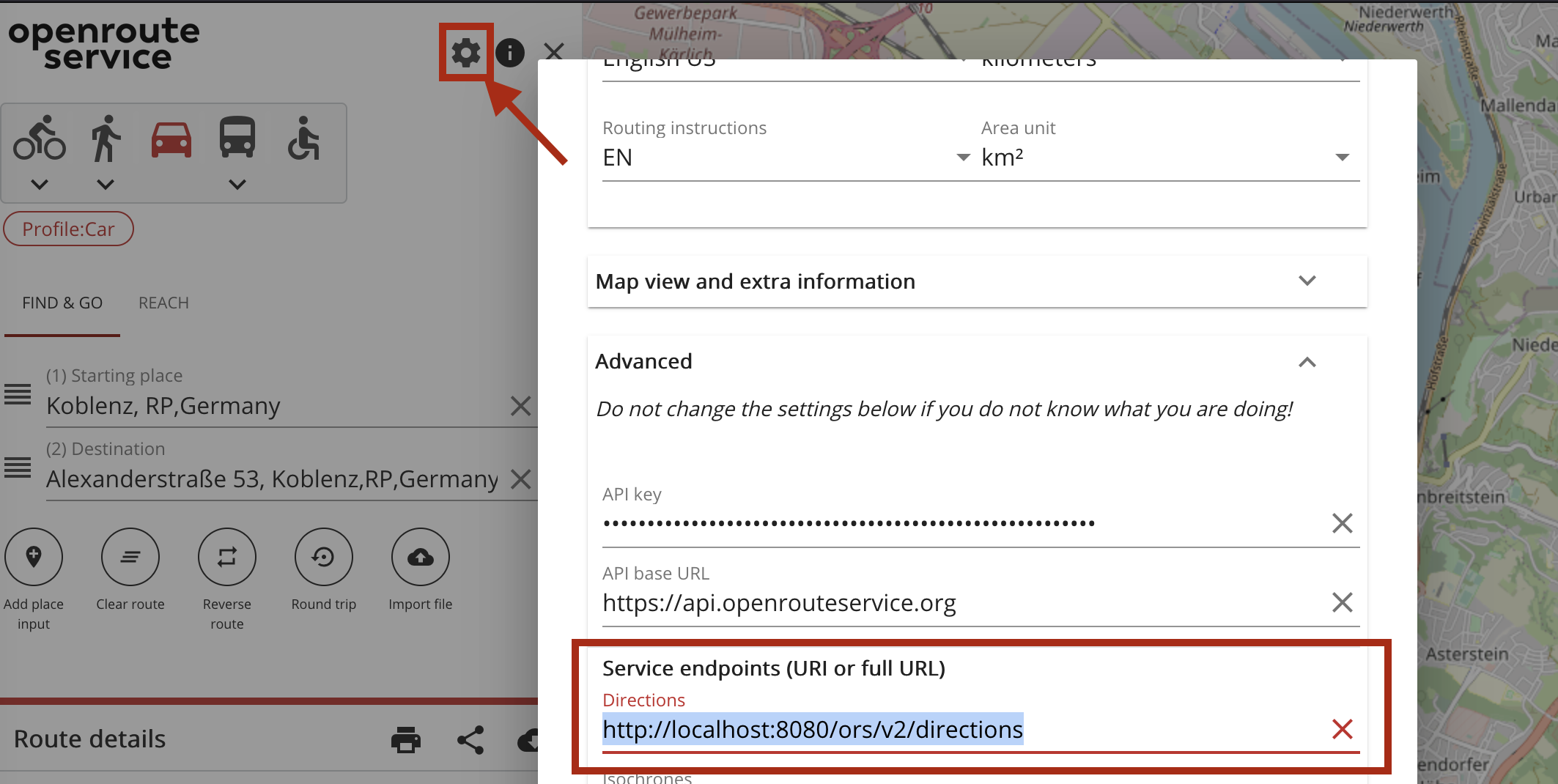
let orsDirections = new Openrouteservice.Directions({ host: "http://localhost:8082/ors" }Web client: Open the ORS web client. Open the settings using the button located at the top right of the side menu. Open the ‘Advanced’ tab and in section ‘Service endpoints (URI or full URL)’ replace the field ‘Directions’ with your local one:
http://localhost:8080/ors/v2/directions. Click ‘save’ and you are good to go!classic-webclient: Access the classic-webclient here. Click on the small gear button located at the top right of the left navigation bar. Again click on the very light grey gear symbol on the bottom left(hard to see, just try to hit it somewere there). Developer Options appear. Change the BaseUrl to your local one:
http://localhost:8080/ors/v2/. Click on change Endpoints. You are good to go!
You can save this config to cookies to make the change persistent when you leave the website and come back later, otherwise it will be resetted to the requests against the public API. Just tick the box next to the Change Endpoints button.
Alter the ORS config file#
By default only car profiles are activated.
Edit the config file located at docker/conf/ors-config.json
Add “walking” in the array active in line 119:
"init_threads": 1,
"attribution": "openrouteservice.org, OpenStreetMap contributors",
"elevation_preprocessed": false,
"profiles": {
  "active": [
    "walking"
  ],
If you are interested in cycling and car profiles you can add “bike-regular” and “car” as well separated by a comma.
You find a thorough documentation of the config file and its options in the wiki here GIScience/openrouteservice.
After you altered the config file, restart your docker instance as before when we changed the pbf file.

